The Marshall Fire ignited on December 30, 2021 near Boulder, Colorado during an extreme Chinook wind event. Sustained winds of 100+ mph drove the fire through grassland into suburban neighborhoods, burning over 6,000 acres and destroying more than 1,000 homes in just a few hours. It remains the most destructive wildfire in Colorado history by structure count.
This case study demonstrates how to integrate real geospatial data sources with Wildfires.jl’s component interface to simulate the Marshall Fire’s early spread.
Loading Geospatial Data
Pre-processed LANDFIRE terrain rasters and HRRR wind data are stored as GeoTIFF files. We load them with Rasters.jl and wrap them with GeoSurrogates.RasterWrap for fast bilinear interpolation.
HRRR provides 10m u/v wind components and surface gusts at ~3 km resolution. We load nine snapshots at 15-minute intervals (17:00–19:00 UTC) from the NOAA HRRR archive on AWS — three hourly analyses plus sub-hourly forecasts — and build a WindField that interpolates in both space and time.
Code
struct WindField times::Vector{DateTime} u_wraps::Vector{<:RasterWrap} v_wraps::Vector{<:RasterWrap} gust_wraps::Vector{<:RasterWrap}endfunctionload_wind_field(datadir, suffixes, times) u_wraps = [RasterWrap(Raster(joinpath(datadir, "wind_u_$s.tif"))) for s in suffixes] v_wraps = [RasterWrap(Raster(joinpath(datadir, "wind_v_$s.tif"))) for s in suffixes] gust_wraps = [RasterWrap(Raster(joinpath(datadir, "wind_gust_$s.tif"))) for s in suffixes]WindField(times, u_wraps, v_wraps, gust_wraps)endfunctionwind_at(wf::WindField, lon, lat, dt::DateTime) times = wf.timesif dt <=first(times)return_wind_snapshot(wf, 1, lon, lat)elseif dt >=last(times)return_wind_snapshot(wf, length(times), lon, lat)end i =searchsortedlast(times, dt) t1, t2 = times[i], times[i +1] alpha =Dates.value(dt - t1) /Dates.value(t2 - t1) w1 =_wind_snapshot(wf, i, lon, lat) w2 =_wind_snapshot(wf, i +1, lon, lat)return (u = (1- alpha) * w1.u + alpha * w2.u, v = (1- alpha) * w1.v + alpha * w2.v, gust = (1- alpha) * w1.gust + alpha * w2.gust)endfunction_wind_snapshot(wf::WindField, i, lon, lat) (u =predict(wf.u_wraps[i], (lon, lat)), v =predict(wf.v_wraps[i], (lon, lat)), gust =predict(wf.gust_wraps[i], (lon, lat)))endwind_field =load_wind_field(DATADIR, WIND_SUFFIXES, WIND_TIMES)nothing
Custom Components
To plug real data into the simulation, we define custom AbstractFuel, AbstractWind, and AbstractTerrain subtypes. These convert from the simulation’s local meter-based grid to geographic (lon/lat) coordinates for spatial lookups.
Code
usingWildfires.Rothermel: NFFL_MODELS, nffl_modelstruct MarshallFuel <: AbstractFuel fuel_wrap::RasterWrap lon0::Float64 lat0::Float64endconst NON_FUEL_CODES =Set([92, 93, 98, 99]) # snow/ice, ag, water, barrenfunction (f::MarshallFuel)(t, x, y) lon = f.lon0 + x / M_PER_DEG_LON lat = f.lat0 + y / M_PER_DEG_LAT code =round(Int, predict(f.fuel_wrap, (lon, lat))) model =nffl_model(code)# Unrecognized codes (including 91/urban) fall back to SHORT_GRASSreturn model !==nothing ? model : SHORT_GRASSendfunctionis_non_fuel(f::MarshallFuel, x, y) lon = f.lon0 + x / M_PER_DEG_LON lat = f.lat0 + y / M_PER_DEG_LAT code =round(Int, predict(f.fuel_wrap, (lon, lat)))return code ∈ NON_FUEL_CODESendnothing
Code
struct MarshallWind <: AbstractWind field::WindField start_time::DateTime lon0::Float64 lat0::Float64 adjustment::Float64 # 10m wind → midflame adjustmentendfunction (w::MarshallWind)(t, x, y) lon = w.lon0 + x / M_PER_DEG_LON lat = w.lat0 + y / M_PER_DEG_LAT dt = w.start_time +Second(round(Int, t *60)) wnd =wind_at(w.field, lon, lat, dt)# 10m mean wind speed (Rothermel is calibrated for sustained wind) speed_kmh =hypot(wnd.u, wnd.v) *3.6* w.adjustment# FROM direction in math convention (CCW from +x/east):# HRRR u = eastward, v = northward; negate to get FROM direction direction =atan(-wnd.v, -wnd.u)return (speed_kmh, direction)endstruct MarshallTerrain <: AbstractTerrain slp_wrap::RasterWrap asp_wrap::RasterWrap lon0::Float64 lat0::Float64endfunction (t::MarshallTerrain)(_, x, y) lon = t.lon0 + x / M_PER_DEG_LON lat = t.lat0 + y / M_PER_DEG_LAT slp_deg =predict(t.slp_wrap, (lon, lat)) slope =tan(deg2rad(clamp(slp_deg, 0.0, 80.0)))# LANDFIRE aspect is azimuth (°CW from north) — convert to math convention (rad CCW from east) aspect =π/2-deg2rad(predict(t.asp_wrap, (lon, lat)))return (slope, aspect)endnothing
Simulation
We set up a level set grid covering the Marshall Fire extent (~8.7 km x 6.3 km at 30 m resolution) and run a 2-hour simulation with spatially varying LANDFIRE fuel data and the Chinook wind field.
Code
# Grid setup: 290 x 210 cells at 30mnx, ny =290, 210dx =30.0# Offsets so ignition point (0, 0) maps to IGNITION_POINT in lon/latx0 =-(IGNITION_POINT.lon - EXTENT.X[1]) * M_PER_DEG_LONy0 =-(IGNITION_POINT.lat - EXTENT.Y[1]) * M_PER_DEG_LATg =LevelSetGrid(nx, ny, dx=dx, x0=x0, y0=y0)ignite!(g, 0.0, 0.0, 60.0)# Componentsfuel =MarshallFuel(fuel_wrap, IGNITION_POINT.lon, IGNITION_POINT.lat)wind =MarshallWind(wind_field, DateTime(2021, 12, 30, 17), IGNITION_POINT.lon, IGNITION_POINT.lat, 0.31)terrain =MarshallTerrain(slope_wrap, aspect_wrap, IGNITION_POINT.lon, IGNITION_POINT.lat)moisture =UniformMoisture(FuelClasses(d1=0.03, d10=0.04, d100=0.05, herb=0.30, wood=0.50))# Mark non-fuel cells (water, agriculture, snow/ice, barren) as unburnablexs =collect(xcoords(g))ys =collect(ycoords(g))for j ineachindex(xs), i ineachindex(ys)ifis_non_fuel(fuel, xs[j], ys[i]) g.t_ignite[i, j] =NaNendendmodel =RothermelModel(fuel, wind, moisture, terrain, EllipticalBlending())trace =Trace(g, 20)nothing
Simulation complete: t = 44.8 min, burned = 4840 cells
Component Overview
After simulation, fireplot(grid, model) provides a multi-panel view of the fire state alongside all environmental inputs. The fire front (red contour) is overlaid on each panel for spatial reference.
Code
fireplot(g, model)
Toggle individual panels or enable the spread rate field:
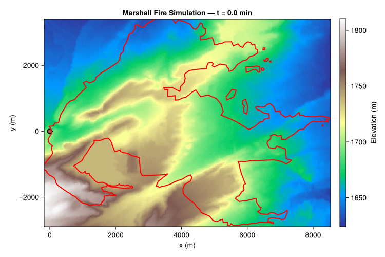
Fire spread animation with the observed perimeter (solid red) overlaid. The simulated perimeter is shown with a black outline and semi-transparent red fill over terrain elevation.
Results
Note
This simulation uses spatially varying LANDFIRE fuel data (NFFL 1–13 fuel models) with constant moisture and covers only the first ~2 hours of a fire that burned for over 24 hours. Wind data comes from HRRR 10m mean wind at 15-minute resolution, scaled to midflame height (adjustment factor 0.31). Non-fuel LANDFIRE cells (water, agriculture, snow/ice, barren) are marked as unburnable. LANDFIRE urban cells (code 91) are not in the NFFL fuel model table, so they fall back to SHORT_GRASS — a rough approximation that allows fire to spread through developed areas, consistent with the Marshall Fire’s rapid structure-to-structure ignition. The real fire’s spread was further intensified by extremely dry conditions (record low humidity), decades of grass accumulation in the wildland-urban interface, and ember transport — factors not captured in this basic Rothermel surface fire model.